
DORRIGO PLATEAU CORRIDOR DIGITAL MAPPING AND KOALA RESTORATION PROJECT


Mapping Koala Corridors Dorrigo Plateau
DORRIGO PLATEAU CORRIDOR DIGITAL MAPPING
AND KOALA RESTORATION PROJECT
This two-year Dandarrga Landcare project received grant funding from the Australian Government* and includes mapping of vegetation in three biodiversity corridors on the plateau, conserving and adding to existing habitat through regeneration and enrichment planting of 2560 plants along and adjacent to the Mackay’s Creek Rd corridor, and fencing habitat from stock with wildlife friendly fencing.
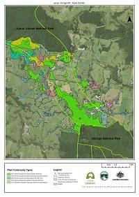 |
The Dorrigo Plateau is a unique landscape. It lacks comprehensive digital vegetation mapping, so we started with the most important bits: the regional biodiversity corridors. Vegetation mapping is crucial for understanding plant communities and planning effective landscape rehabilitation. It helps landholders select the right native species mix for restoring disturbed areas and plan their land use accordingly. Find Project Resources and Maps here Contact dandarrga@gmail.com |
https://landcare.nsw.gov.au/groups/dandarrga-landcare/plateau-koalas-project/
*Threatened Species Commissioner, Department of Climate Change, Energy, the Environment and Water